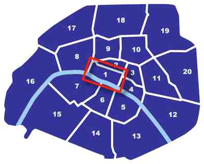
Here is a fabulous Google map of Paris
This blue map of Paris gives you a bit of an idea of the shape of the area which is broken up into districts/suburbs or arrondissements. There are 20 arrondissements, with the first (most expensive area) in the centre, on the northern side of the River Seine (see the “1” in the red box below). As you follow the numbers from 1 to 20, you will notice that all the districts start to create a curling shape, sort of like a snail shell (well, that’s how I think of it ). The outer suburbs are surrounded by a “ring road” called le Peripherique (that’s right, “the periphery”, the outside boundary).

How to get around this map of Paris
In the top left corner of the map, you will see some little arrows and a PLUS and MINUS sign. Click the PLUS sign to ZOOM IN for a closer view of the streets etc. Click the MINUS sign to ZOOM OUT for a country view.
[mappress mapid=”1″]
I love Paris for so many reasons, one of which is because it’s so easy to find your way around. :-)
Once you zoom in a bit you’ll be able to see the street names very easily, and will be able to navigate your way around. See the River Seine? Very cool :-)
[mappress mapid=”2″]
When I first moved to Paris, I bought a little red book which was a perfect fit in my handbag, and even in the back pocket of my jeans – it was called a PLAN DE PARIS, and was invaluable. I never left home without my MAP OF PARIS! If you don’t already own one, you might consider doing so.
There’s also a different way of looking at these maps – one way actually shows you the names of buildings and is great to get a bird’s eye view of the actual cars in the street!


LET'S CHAT